Protecting Aboriginal heritage at Lake Mackenzie
Since 2017, we've been working with the Tasmanian Aboriginal community to improve the management of Aboriginal heritage at Lake Mackenzie.
Lake Mackenzie sits within the Central Plateau Conservation Area, part of the Tasmanian Wilderness World Heritage Area. The lake was formed in 1972, following construction of Mackenzie Dam and is the highest water storage in the Mersey Forth hydroelectric scheme. This scheme contributes approximate 338 megawatts, or 16% of the state’s electricity, annually.
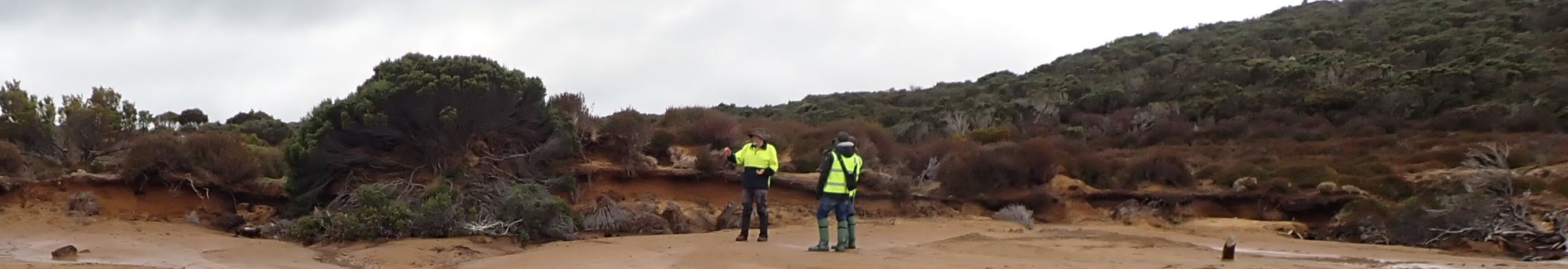
Mackenzie Dam inundated the original, smaller Lake Mackenzie and two seasonal wet areas – Sandy Lake and the Pine Marsh wetland to the north. Over the years, seasonal fluctuations in the water level have eroded soils and exposed stone artefacts around the shore. In some locations, old land surfaces are also being exposed and degraded: the most significant of which are the alpine lunettes and depositional sand sheets.
In 2020, we started monitoring erosion at one of the formally recognised Aboriginal heritage sites. In 2021 and 2022, we laser scanned this site again and compared it against our baseline data. We noted bank retreat, likely due to the increased frequency and duration of high-water through the 2022 winter. In consultation with the Aboriginal community and Wild Ecology we've recently developed a rehabilitation plan for this site and are seeking statutory approval, ahead of starting work in early 2025.
Managing artefacts
Not only does erosion impact landscapes, it can also affect heritage sites, displacing artefacts from their original locations. At Lake Mackenzie, stone artefacts have been found at multiple sites around the original lake shores. They can tell us important stories about what people in the past ate, the things they made, where they were from and how they interacted with each other.
To hear those stories as clearly as possible, we need to understand how recent water movements have moved these artefacts around the landscape. Since 2022, we've been working with the Tasmanian Parks and Wildlife Service's Working on Country team to make, deploy and track imitation artefacts within the landscape. Their movements will be monitored over several years and the results will help us better manage the true heritage of Lake Mackenzie. We're also hoping to return genuine displaced artefacts back to site.
Get involved!
Would you like to participate in upcoming management works at Lake Mackenzie? In early 2025, we'll be returning to complete further erosion rehabilitation works and continue the artefact dispersal surveys. Please contact one of the project team.
Be part of the conversation
Good to see this, landslip can be a historical loss for many. i wish i was healthy enough to help. Just like the video i live in a landslip area and have stopped a lot of landslip in this way, so i know it works, i would be very interested in seeing other videos of the progress made and finished landfill. thank you, and regards Robyn Brown (madden name Gower)
Who's Listening
-
Aboriginal Heritage Officer
Phone 0414 711 576 Email cjpedder44@gmail.com -

Phone 6240 4623 Email helga.grant@hydro.com.au -
Environmental Scientist (Heritage)
Lake Mackenzie Rehabilitation Plan

Project Timeline
-
Dec 2012 - Mar 2016
Protecting Aboriginal heritage at Lake Mackenzie has finished this stagePreliminary surveys
We completed archaeological surveys and a property survey to map heritage sites around the shoreline.
-
From Mar 2017
Protecting Aboriginal heritage at Lake Mackenzie has finished this stageCommunity engagement
Community participation is critical. In the first instance, we facilitated 3 community visits for:
- The Tasmanian Aboriginal Centre (May 2017)
- Six Rivers Aboriginal Corporation and Trainee Aboriginal Rangers from Parks and Wildlife Service (February 2020)
- The Department of Education's Aboriginal Education team and DCNSTRCT film crew (April 2021)
In late 2021, we then launched this site to facilitate and support engagement with the broader Tasmanian Aboriginal community. We continue to work closely with the community to ensure they're involved in management decisions and activities.
-
2020 - 2023
Protecting Aboriginal heritage at Lake Mackenzie has finished this stageErosion Modelling and Monitoring
A laser scanner and drone were used to create a detailed 3D model of the landscape.
We will use the model as a baseline against which to measure future erosion. It will also help us understand what factors are driving the erosion and inform how best to manage it.

To date, monitoring suggests the following factors are playing the most significant role in erosion:
waves at high water levels
frost heave
seepage induced erosion from drainage through the sand bank
-
Ongoing
Protecting Aboriginal heritage at Lake Mackenzie has finished this stageModelling artefact dispersal
To better understand how stone artefacts might move within the landscape, you can create and track fake artefacts.
From Feb 2022. we've worked with Tasmanian Parks and Wildlife Service's Working on Country team to make, deploy and track imitation artefacts made from a range of materials including coloured glass and porcelain. A microchip was embedded in each imitation artefact.


Unfortunately, some of the artefacts were mistakenly removed shortly after they were deployed, so we will return in 2024 to try again.
-
Nov 2023
Protecting Aboriginal heritage at Lake Mackenzie is currently at this stagePermit Process
We have lodged a permit application with the Aboriginal Heritage Council and hope to start work on the recommended rehabilitation plan in early 2025.
-
Mar 2025 - April 2025
this is an upcoming stage for Protecting Aboriginal heritage at Lake MackenzieGetting to Work
We'll be continuing site monitoring, undertaking rehabilitation works and re-deploying imitation artefacts.
Send us a message to get involved.